RISS – Real-Time Interactive Security Status App
RISS App (Real-Time Interactive Security Status) app where users may report, locate, monitor, and coordinate responses to incidents from the moment they occur through resolution.
RISS (Real Time Interactive Security Status) App
A real-time security communication and incident management app developed for schools, neighborhood watch organizations, security personnel, and other groups that need to know what is happening, where it is happening, and how a response is progressing.
Real-Time Security Awareness & Response
RISS fills the critical knowledge gap between being notified that an incident is occurring and knowing that it has been resolved.
RISS members instantly see the incident location, activity, and status on an interactive map, When an incident is reported
Members can also See the locations of first responders and receive direction and updates from administrators and First Responders.
Members respond with greater awareness and confidence to the incident, as there is an understanding of the situation based on shared, real-time information.
Coordinated Response
RISS connects administrators, first responders, staff, and parents through a common real-time security environment.
Administrators can remotely monitor reported incidents, understand the incident activity and severity, view member and incident locations, and Provide Direction to members and first responders as an incident develops.
First Responders See and Move To the incident, can see the incident location on a map, Monitor reported Activity and Status, all While Receiving Admin direction.
All May Report an incident and immediately View Relevant Information including the incident location, reported severity, first responder locations, and directions or updates from administrators and responders.
Easy-to-Understand User Interface:
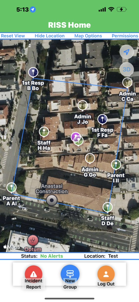
RISS uses color-coded user identification to make the shared map easier to understand at a glance:
Yellow Marker— Administrators
Blue Marker— First Responders
Green Marker— Parents and Staff
Purple Marker— An individual’s own location, visible only to that individual
Red Marker and line – indicating Location and Direction of the Incident itself
This visual identification helps users quickly distinguish roles and locations during an active incident.
Monitor Multiple Locations
Using RISSHuB Services, users can monitor multiple locations simultaeously or join any one of several existing locations. if a location you need does not exist, we can develop a new customized location. RISS is designed to scale beyond a single facility. Authorized users have access to multiple Locations from a single login.
Alternatively, RISS App users may join other independent RISS databases managed by RISS Privileged Administrator App Users.
How RISS App Works
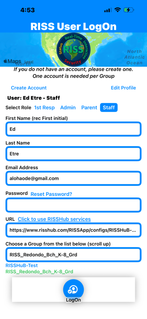
Start RISS – > RISS User Logon
After creating an account, logon is simple:
- Tap Start RISS -> RISS User Logon
- Select a role and fill in the logon form, Role is required, Names are optional.
- Tap “Click to use RISSHuB Services”, and a URL will be filled in for you. If you are not using RISSHub services, your RISS database manager should provide a URL to use.
- A list of RISS Real-Time databases will appear below “Chose a group from ..”, Tap RISS_Redondo_K-8_Grd, and that will be written into “Chose a ..”.
- Tap Logon
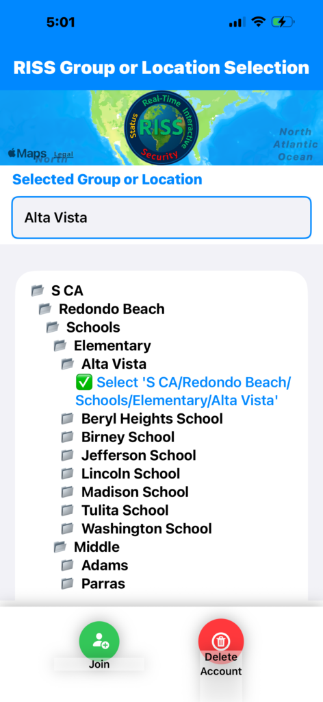
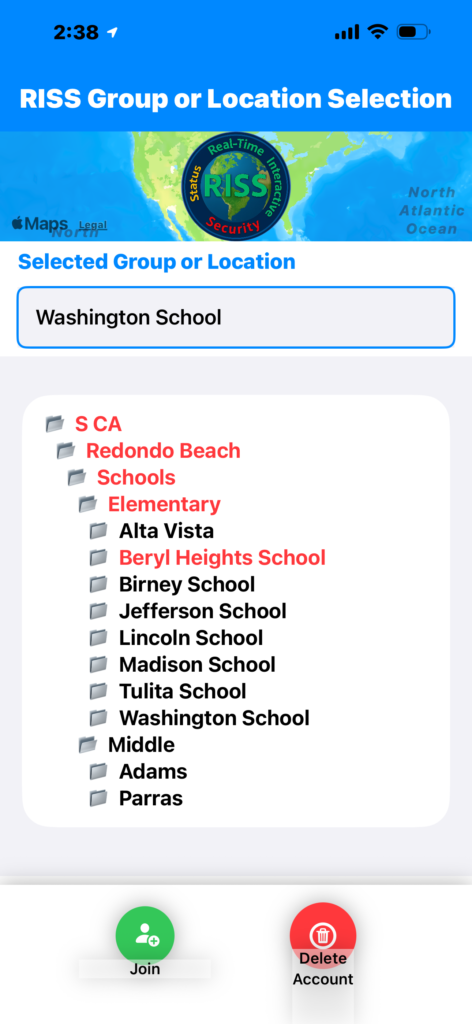
RISS User Logon -> RISS Group or Location Selection
A user can remain here if they wish to monitor all locations simultaneously for incident occurrence. If an incident occurs an alarm will sound and the location of the incident occurrence will turn red. This feature was added with special consideration for First Responders and Parents.
- Tap a folder with the name of the Location you want to join
- Tap Select .. and the location will appear in the “Selected Group or Location” Box
- Tap Join to Go to the Home page of that Location
RISS Group or Location Selection -> RISS Home
RISS Home provides a map that features a blue boundary location, and user locations that are colored coded for quick identification of Roles and Incident Location if occurred.
Status and Location are shown. If an incident is reported, an alarm will sound and the background will turn red and status will be updated.
The user can then Tap Incident Report, to see a detailed summary of the incident.
Tap Incident Report (IR) to generate a new IR, if one has not been reported.
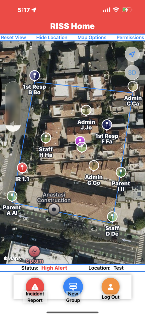
Press New Group to return to RISS Group or Location Selection. Press Logout to logout.
RISS Home -> Incident Update
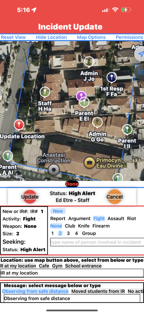
As an example, say a member sees a group starting to fight in a local park while on a neighborhood watch, AFTER CALLING 911, they use RISS App. From RISS Home Tap Incident Report, Incident Update appears as there is no previous report.
Begin View
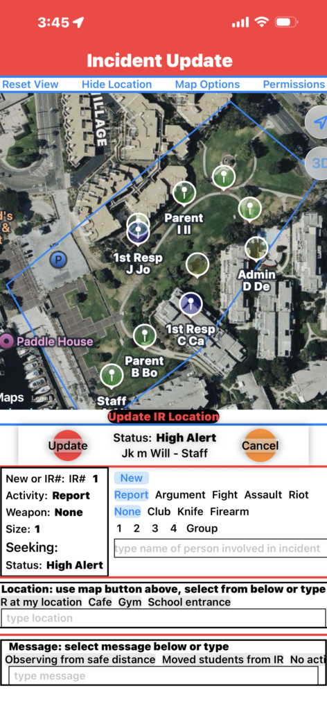
- Tap Update IR Location and then Tap the Map where then location is, a Red Marker appears
- Activity – Tap Fight
- Size – Tap Group
- Fill in Location and Message, Tap a pre-select, or Tap the box (a keyboard and mic will appear, use either to fill in the detail)
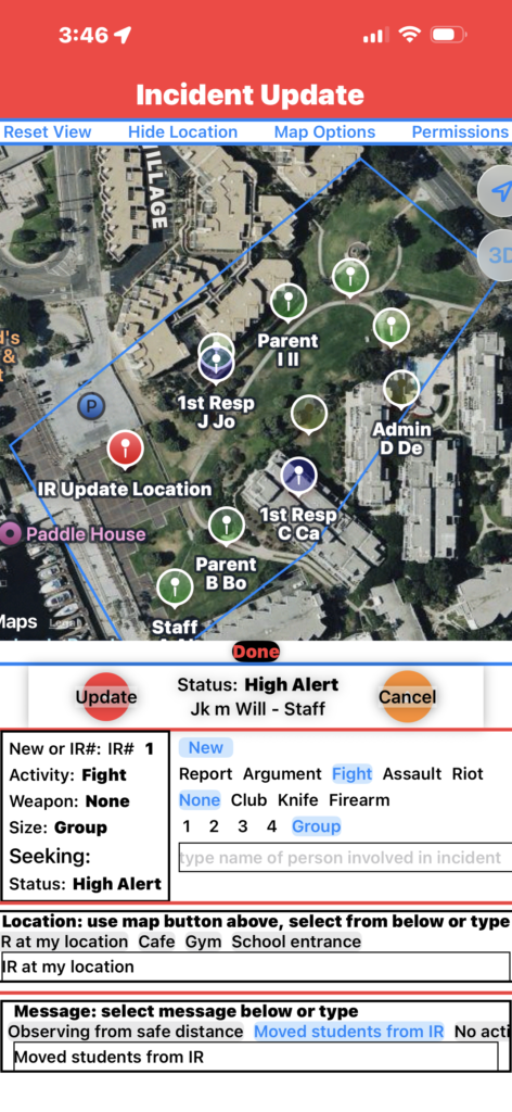
- The screen now looks like the one on the right
- Tap Update and Incident Report Summary appears
Filled In
Incident Update -> Incident Report Summary
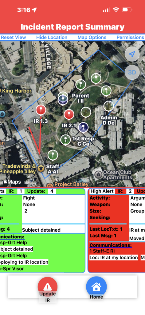
Incident Report Summary Appears and shows:
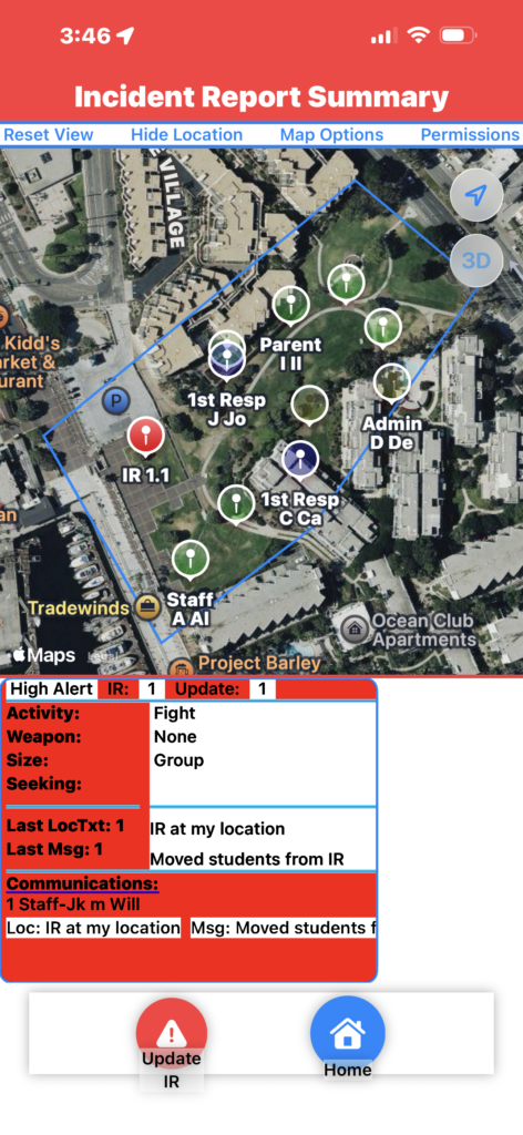
- Red Marker IR1.1 – Map location of Incident Report 1, Update 1
- Headline
- High Alert – from Status
- IR 1 – Incident Report Number 1
- Update 1 – Update Number 1
- Activity – Fight
- Size – Group
- Last Location Text and Update Number
- Last Message Text and Update Number
- History of Location, and Message Texts, who sent them, and their Update Numbers
Tap Update IR
Incident Report Summary -> Incident Update
Incident Update Appears
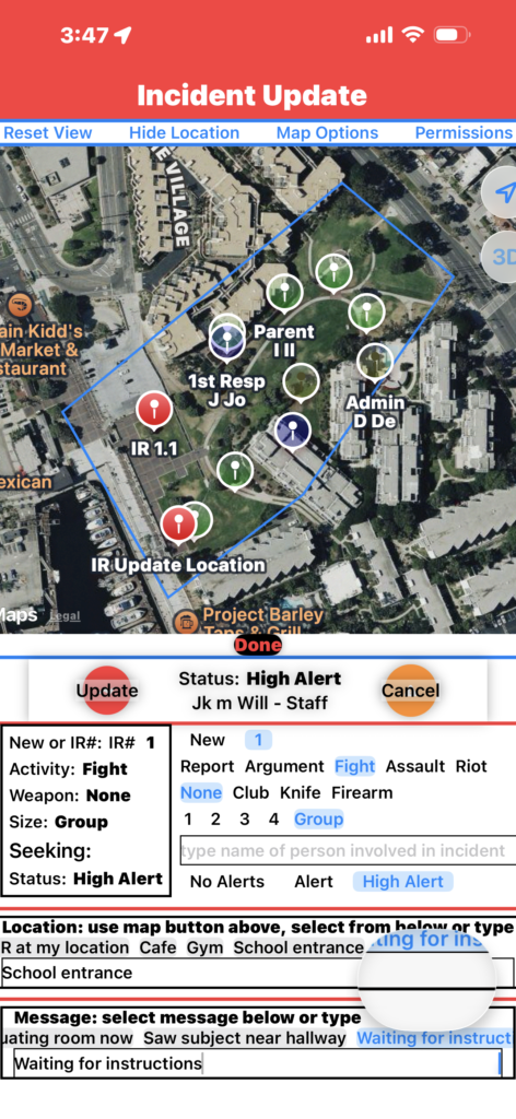
IR Number 1 is pre-selected:
- Information from the previous Update is filled in for:
- Activity
- Weapon
- Size
- Seeking
- Status
- Information from the previous Update is Not filled in for:
- Location Text
- Message Text
User updates Incident by:
- Tap Update IR Location and then Tap the Map where then new IR location is, a new Marker appears
- Updates Location Text
- Updates Message Text
- Tap Update
Incident Update -> Incident Report Summary
Incident Report Summary Appears and shows:
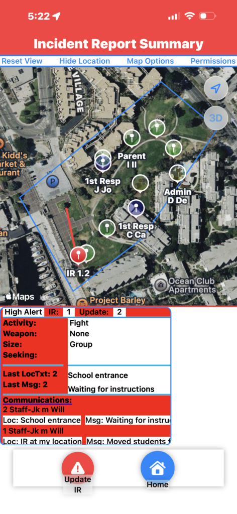
- Red Marker IR1.2 – Map location of Incident Report 1, Update 2
- Red Line – Line to Marker indicates incident direction
- Headline
- High Alert – from Status
- IR 1 – Incident Report Number 1
- Update 2 – Update Number 2
- Activity – Fight
- Size – Group
- Last Location Text and Update Number
- Last Message Text and Update Number
- History of Location, and Message Texts, who sent them, and their Update Numbers
The Upper Blue Command Bar and Showing Location
User locations will not show if they are a certain distance outside the boundary, that distance is set by the RISS database manager.
User location update time is set to be slow, and increased when an incident has occurred.
Showing Location is always optional and can be turned off at any time using the Hide Location command or by using the Permissions command and changing location permissions on your phone.
Reset View – Recenters the map around the Boundary
Hide Location – turns the current user location off and they are not shown
Map Options – for basic, topic, or detailed choice of map
Permissions – shows the user the Location Permission Screen on their phone so they can turn permissions off or on